Dear Jeff and Mayor Shantz,
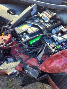
Thank you for your assistance and consideration following the serious July 23 collision involving my wife, Brigitte, at the intersection of Beitz Road and Crowsfoot Road.
Attached is my Road-Safety Review Request for consideration by Woolwich Township Council at its August 25 meeting.
My purpose in submitting this information is not to determine blame or legal responsibility. My hope is simply to raise awareness of several conditions at this intersection that I believe deserve professional assessment so that the risk of another serious collision may be reduced.
The concerns include:
- restricted sight lines associated with seasonal crops and vegetation;
• the location and visibility of the stop line;
• actual traffic speeds and traffic volumes on Crowsfoot Road;
• speed-limit and other safety signage;
• road and shoulder conditions; and
• the increasing use of this intersection by horse-drawn buggies, including a buggy transporting Mennonite schoolchildren during busy morning and afternoon traffic periods.
The horse-and-buggy issue is particularly important because the position of a buggy driver relative to the horse and the much slower time required to enter and clear an intersection may create sight-line requirements different from those of an automobile.
Brigitte had approximately 60 years of accident-free driving before this collision. She suffered very serious injuries and faces a lengthy period of treatment and rehabilitation.
Having lived on Beitz Road for approximately 43 years, I would very much like something constructive to come from this painful experience.
I respectfully ask Council to consider directing the appropriate Township staff to undertake a comprehensive engineering and road-safety assessment of this intersection and recommend reasonable measures that could improve safety for motorists, horse-and-buggy users, schoolchildren, cyclists and all others who travel through this area.
Because of my present physical and emotional health, I will not be attending the August 25 meeting in person. I am grateful that the Council is willing to consider my written submission on our behalf.
Jeff, would you please confirm that this Road-Safety Review Request and its supporting documentation will be included for Council’s consideration on August 25?
Thank you to Mayor Shantz and all members of Council for taking the time to consider this request.
My hope is very simple: less suffering and greater safety for everyone using this intersection.
Respectfully, George Ross Clark
Phone: 519-648-2985
Road-Safety Review Request – Beitz Road at Crowsfoot Road
Updated Council brief for the Township of Woolwich • August 25, 2026
| Purpose
To reduce the risk of another serious collision by asking for a comprehensive, evidence-based review of sight lines, seasonal crops, vehicle speeds, signs and markings, road/shoulder geometry, and horse-drawn buggy traffic — including school children transportation. This brief is a safety request, not a finding of legal fault. |
| Collision | July 23, 2026, approximately 12:35 p.m. |
| Location | T-intersection of Beitz Road and Crowsfoot Road, Woolwich Township |
| Submitted by | George Ross Clark |
| Council meeting | Tuesday, August 25, 2026 |
| Attendance | Written submission; Mr. Clark does not plan to attend in person for health and family-care reasons. |
Central request to Council
Please direct staff to complete a comprehensive safety assessment and report back with measured findings, interim protections where warranted, and practical prevention options before another growing season.
Prepared as a public-safety research brief. Facts requiring engineering, police, survey or legal verification are identified as such.
BEITZ ROAD / CROWSFOOT ROAD | ROAD-SAFETY COUNCIL BRIEF
- Executive Summary
This request has broadened from a single sight-line concern to a systems-level rural road-safety review. The July 23 collision is the reason for examining the location now; the goal is to identify practical measures that could reduce risk for every road user.
Sight line and seasonal crop: the family reports mature corn about 84 inches (approximately 2.1 m) high close to the corner on the driver’s left. Woolwich Zoning By-law section 4.15 establishes a 6.0 m sight triangle and limits vegetation within it to 0.75 m above road grade. Exact crop location and property/road lines require municipal measurement or survey.
Speed: Mr. Clark reports that vehicles on Crowsfoot Road often appear to be travelling substantially faster than 80 km/h, with personal estimates ranging roughly from 90 to 130 km/h. These are observations, not measured speeds. A formal speed study is requested rather than relying on estimates.
Horse-and-buggy traffic: Mr. Clark reports increased Mennonite horse-drawn buggy use at this intersection, including a buggy transporting schoolchildren during morning and afternoon periods when traffic is heavier. This creates an additional vulnerable-road-user reason for a full safety review.
Roadside operating space: the concern should be described as limited usable shoulder/roadside operating space, not simply “road allowance.” A road allowance is the legal public right-of-way and can be wider than the pavement and shoulder. Staff should measure both the legal right-of-way and the usable roadway/shoulder condition.
Signs and markings: Mr. Clark reports no clearly visible 80 km/h speed-limit sign near the intersection and that the stop line is difficult to see. Ontario generally uses an 80 km/h maximum on roads outside cities, towns and villages where no different speed is posted, so the legal speed limit and the adequacy/placement of signs should be confirmed by the Township rather than assumed from the absence of a sign.
Enforcement and local experience: Mr. Clark has lived on Beitz Road for approximately 43 years and reports that police presence on Crowsfoot Road is uncommon. This is useful local context but should be supplemented by objective collision, complaint, enforcement and speed data.
| Important context about the driver
The family reports that Brigitte had driven for approximately 60 years without a prior collision before July 23. That history is included as human context and a reason to examine the road environment carefully; it is not presented as proof of fault or legal responsibility. |
Figure 1. Schematic based on the resident account. Not a survey, collision reconstruction, or finding of vehicle speed or fault.
BEITZ ROAD / CROWSFOOT ROAD | ROAD-SAFETY COUNCIL BRIEF
- Separate Known Facts, Resident Observations, and Questions to Measure
Keeping these categories separate will make the Council submission stronger, more credible, and easier for staff to act on.
| Category | What can be stated now | What should be verified |
| Documented / stable | A serious collision occurred July 23 at about 12:35 p.m.; Brigitte sustained serious injuries requiring hospital care and rehabilitation. | Police report and official collision record. |
| Driver account | She stopped at Beitz Road, looked left and right, did not see the SUV before beginning the left turn; tall corn was reported to restrict the left view. | Driver eye position, stop position, available sight distance, crop edge and height. |
| Local observation | Vehicle speeds often appear above the expected rural limit; police presence is reported as rare. | 7-day or longer automated speed/volume study and WRPS enforcement/collision data. |
| Local observation | Horse-and-buggy use has increased, including schoolchildren transport at busy times. | Counts/observations at school travel times and respectful consultation with local Mennonite community/school representatives. |
| Local observation | Limited usable shoulder/roadside space for buggies; stop bar difficult to see; no clearly visible 80 km/h sign near the intersection. | Roadway/shoulder widths, legal road allowance, pavement marking condition, legal speed limit and sign inventory/placement. |
A document consistency correction
The existing six-scene sight-line storyboard uses an approximate corn height of 2.6 m on slide 5, while the current account and the earlier written submission use 84 inches / approximately 2.1 m. Before the storyboard is filed with Council, standardize this to the best-supported figure — preferably “approximately 2.1 m (84 inches), resident estimate” — unless an actual measurement supports a different number.
Why horse-drawn traffic belongs in the review
Woolwich’s own Roads and Sidewalks information expressly describes safe travel for motorized and horse-drawn vehicles as part of Infrastructure Services’ role. The Township’s Active Transportation Master Plan also recognizes the safety of horse-drawn buggies in transportation planning, including on Crowsfoot Road. Ontario’s driver guidance tells motorists encountering horse-drawn vehicles to slow down, use caution, maintain a safe following distance, and pass only when safe. These sources support treating buggy use as a normal road-safety design consideration, not as an unusual exception.
Why car and buggy driver positions must be assessed differently
Planning geometry supplied by the resident: for a typical single-horse, four-wheeled buggy, use approximately 18 ft (5.5 m) overall from the horse’s nose to the back of the buggy and approximately 12 ft (3.7 m) from the horse’s nose to the driver’s seated position. These are planning estimates only; actual local buggy and horse dimensions should be measured or confirmed by Township staff.
| Road-user position | Approximate geometry at a stop line | Safety implication |
| Passenger car | Driver’s eye position can be assessed close to the vehicle’s front stop position; the vehicle does not project many metres ahead of the driver. | A sight-line video made from a car at the stop line is useful for the passenger-car condition, but it does not reproduce buggy geometry. |
| Buggy: horse’s nose held at stop line | Using the planning estimate, the driver may be about 12 ft (3.7 m) behind the stop line. | The driver may have a more restricted view than the car driver because the driver is farther back from the intersection. |
| Buggy: driver moves forward to car-like viewing position | If the driver’s seated position is brought near the stop line, the horse’s nose may project about 12 ft (3.7 m) beyond that position. | The horse may enter the intersection area before the buggy driver obtains the same viewing position used for a passenger-car sight-line assessment. |
Practical consequence for the safety review. Township staff should not assume that a sight line shown to be adequate for a passenger car is automatically adequate for a horse-drawn buggy. The assessment should include buggy-specific driver eye position, the forward projection of the horse, time needed for a horse and approximately 18-ft (5.5-m) vehicle combination to enter and clear the intersection, pavement/shoulder operating space, and the behaviour of approaching motor traffic. Particular attention is warranted during school transport periods when children are passengers.
Recommended field test. At the actual intersection, mark the existing stop line and compare: (A) a passenger-car driver eye position; (B) a buggy with the horse’s nose at the stop line; and (C) a buggy driver advanced to the position needed to see approaching traffic. For each position, measure available sight distance to the left and right and compare it with the applicable design/operational requirements. Use a representative local horse and buggy, or verified local dimensions, rather than relying on these planning estimates for the final engineering conclusion.
- Comprehensive Safety Assessment Requested
The strongest request is not “install this one solution.” It is: measure the risks, apply the appropriate standards, implement urgent protection where warranted, and report the findings transparently.
- Preserve and measure the sight line now. Before harvest or alteration, record date-stamped photos/video from a normal driver eye position; locate property and road-allowance lines; measure crop height and crop edge; plot the 6 m zoning sight triangle; and calculate actual available intersection sight distance.
- Conduct an objective speed and traffic study. Collect continuous speed and volume data for at least seven representative days. Report the legal limit, median and 85th-percentile speeds, highest credible recorded speeds, percentage exceeding the limit, vehicle volumes and heavy-truck patterns. Include morning and afternoon school-travel periods.
- Review horse-and-buggy operations. Observe buggy movements, passing behaviour, queueing and conflicts. Include schoolchildren transport periods. Measure pavement width, shoulder width and usable roadside operating space. Conduct a buggy-specific sight-line assessment that accounts for the driver being approximately 12 ft (3.7 m) behind the horse’s nose as a planning estimate, and for an overall horse-and-buggy length of approximately 18 ft (5.5 m). Compare at least three positions: passenger-car driver at the stop line, buggy with the horse’s nose at the stop line, and buggy advanced until the driver has a comparable view. Confirm actual local dimensions before drawing engineering conclusions, and assess the time and distance required for the entire horse-and-buggy combination to safely enter and clear the intersection.
- Review signs, pavement markings and stop position. Confirm the legal speed limit; inventory speed-limit/repeater signs and warning signs; assess stop-sign visibility, stop-line condition and placement; and consider whether an intersection warning, horse-drawn-vehicle warning, speed-feedback display, refreshed/repositioned stop line or other treatment is warranted under engineering guidance.
- Review collision and enforcement history. Compile reported collisions, complaints, near-miss information if available, prior sight-line or vegetation complaints, work orders and recent enforcement. Use measured speed data to determine whether targeted WRPS enforcement is justified.
- Examine seasonal vegetation policy. Determine whether the existing zoning sight triangle and highway-obstruction by-law were complied with, whether they provide sufficient operational sight distance at this specific rural intersection, and whether a seasonal crop inspection/landowner notification program is needed at higher-risk intersections.
- Implement interim measures where warranted. If staff identifies an immediate risk, use the fastest lawful measures available while the full review proceeds — for example vegetation correction, refreshed pavement markings, temporary warning or speed-feedback devices, or other measures selected by the qualified road authority.
- Provide a written report and named follow-up contact. Council should request a staff report that states measurements, standards used, findings, interim actions, permanent options, responsibility for each action, and a target follow-up date.
| One especially important legal/engineering distinction
The zoning sight triangle is a defined minimum regulatory area. It is not automatically the same thing as the full operational sight distance needed for a driver to see approaching traffic at a particular speed. Council should ask staff to assess both. |
- Relevant Woolwich and Ontario Framework
Woolwich Zoning By-law, Part 4, section 4.15. At an intersection of two public road allowances, the by-law defines a sight triangle using points 6.0 m along the property lines and prohibits vegetation within that triangle above 0.75 m over the finished grade of either abutting road. Whether the corn was inside this regulated triangle requires actual boundary and field measurements.
Woolwich Boulevard Maintenance and Highway Obstruction By-law 34-2024, section 13. The by-law states that no person shall restrict sight lines of pedestrians, cyclists or drivers to intersections, driveways, sidewalks, walkways, travel lanes or traffic-control devices. This provides a broader obstruction issue for staff to consider in addition to the fixed zoning triangle.
Woolwich road-safety responsibility and horse-drawn vehicles. The Township’s Roads and Sidewalks page states that Infrastructure Services strives to provide safe travel conditions for all modes, specifically including motorized and horse-drawn vehicles and pedestrians. The same page identifies shoulder drop-offs and signage repairs among road-patrol concerns.
Ontario speed-limit point. The Ontario MTO Driver’s Handbook explains that where no speed limit is posted, the maximum is generally 50 km/h in cities, towns and villages and 80 km/h elsewhere. Therefore, “no visible 80 sign” should be treated as a signage-awareness concern to investigate, not as evidence that no legal speed limit exists.
Ontario horse-drawn-vehicle guidance. MTO guidance instructs motorists who encounter a horse-drawn vehicle to slow down, be very cautious, maintain a safe following distance and pass only when safe. The Highway Traffic Act also contains specific duties when approaching ridden or driven horses. This supports explicit consideration of buggy traffic in speed, passing and road-edge assessments.
Council process. Woolwich Procedural By-law 14-2025 provides that written communications filed with the Clerk are generally included on the agenda for the next meeting, subject to stated exceptions. The official 2026 schedule lists a Council meeting on Tuesday, August 25. Because Mr. Clark is not attending, the practical step is to ask the Clerk to confirm in writing that the final package will be placed before Council on that date.
Recommended Council direction
| Draft motion for consideration
That Council receive the correspondence regarding road safety at Beitz Road and Crowsfoot Road; direct Infrastructure Services and other appropriate staff to complete a comprehensive safety review including intersection sight distance, seasonal vegetation, speed and traffic data, road/shoulder geometry, signs and pavement markings, horse-drawn buggy use including school travel periods, and relevant collision/enforcement history; implement interim measures where warranted; consult affected road users and landowners; and report the measured findings, actions and recommendations back to Council on a target date established by Council. |
- Documentation Package for August 25
To reduce workload and avoid sending many separate emails, submit one indexed package to Jeff Smith, Clerk, and ask that it be circulated to the Mayor, Councillors and appropriate Infrastructure staff.
- Cover letter / one-page request: State the prevention purpose, August 25 request, and that you will not attend in person.
- This Council brief: Keep legal fault and insurance matters outside the public-safety request.
- Sight-line storyboard: Correct the corn-height inconsistency before filing.
- Video/photo index: List each file name, date, recording position, and what it is intended to show. Do not infer speed from ordinary video without professional measurement.
- Resident observation statement: Summarize 43 years on Beitz Road, increased buggy traffic, schoolchildren travel periods, perceived speeding, limited police presence, and sign/stop-line observations; label these as resident observations.
- Site diagram / map and driver-position comparison: Include the intersection schematic and, if available, a municipal/GIS map showing road allowance and property lines. Add a simple car-versus-buggy position diagram showing the planning dimensions of approximately 12 ft (3.7 m) from horse nose to driver and approximately 18 ft (5.5 m) overall. Clearly label the buggy dimensions as illustrative estimates requiring field verification.
- Specific action request: Include the eight-point assessment scope in section 3 and draft Council direction in section 4.
- Evidence kept separate: Keep police records, detailed medical information, insurance correspondence, legal opinions, vehicle data and private witness contacts outside the public Council package unless professional advice says otherwise.
BEITZ ROAD / CROWSFOOT ROAD | ROAD-SAFETY COUNCIL BRIEF
Sources and Materials Reviewed
Official sources are listed first. Accessed August 10, 2026. The legal and engineering interpretation should be confirmed by Township staff and, where relevant, legal counsel.
- Township of Woolwich Zoning By-law, Part 4 – General Regulations, s.4.15 Corner Lots. Official source
- Township of Woolwich Boulevard Maintenance and Highway Obstruction By-law 34-2024, s.13. Official source
- Township of Woolwich – Roads and Sidewalks. Official source
- Township of Woolwich – Active Transportation Master Plan. Official source
- Township of Woolwich Procedural By-law 14-2025. Official source
- Township of Woolwich 2026 Council Meeting Schedule. Official source
- Ontario MTO Driver’s Handbook – Driving Along (speed limits). Official source
- Ontario MTO Driver’s Handbook – Sharing the Road with Other Road Users (horse-drawn vehicles). Official source
- Ontario Highway Traffic Act. Official source
Previously prepared project materials reviewed
Crowsfoot-Beitz-Sight-Line-Storyboard.pptx — educational reconstruction distinguishing driver conduct, visibility, and road/land conditions; includes user-supplied image/video references.
Woolwich Rural Intersection Sight-Line Submission — earlier detailed research and prevention recommendations.
Resident-supplied intersection videos and stop-line photograph referenced in the storyboard and prior submission.
- Engels Coach Shop – Horse-size buggy shaft dimensions. Background dimensional reference; does not establish the exact geometry of local Woolwich buggies.
- Carriage Association of America – Guidance on fitting wheeled vehicles to horses. Background reference illustrating that horse/vehicle dimensions vary and must be matched and verified.
Note: This brief does not determine collision fault, vehicle speed, negligence, or legal liability. It recommends measurements and a municipal safety process.
—